

No photos yet
1Top Snorkeling and Scuba Diving in South Carolina
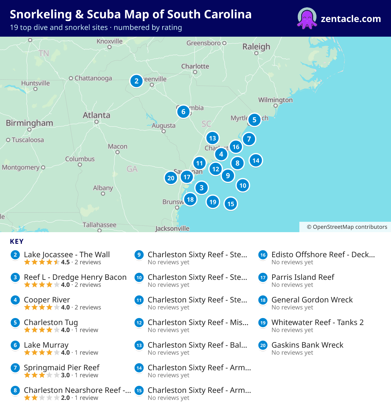
The top 169 dive and snorkel sites in South Carolina, ranked by diver reviews, with maps and photos. Read the South Carolina guide
- dive sites
- 169
- dive shops
- 8
- reviews
- 12
AreasCharleston County58Beaufort County57Georgetown County33Horry County10Oconee County4Pickens County2Berkeley County2Lexington County1
169 sites, ranked by diver reviews
 2
Lake Jocassee - The Wall
4.5(2 reviews)·USA, South Carolina
State designated dive area, walkin from boat ramp, 2 platforms, a skeleton family, a sunk ski boat, tree forest and airplane parts. the lake was flooded in 1973 and a lodge and several buildings still stand at the bottom as well as a cemetery. Devil's Fork State Park
BeginnerMax depth 40 ftShore entry
No photos yet
3Reef L - Dredge Henry Bacon
4.0(2 reviews)·USA, Georgia
23 nm east of Ossabaw Island
BeginnerMax depth 55.1 ftBoat entry
No photos yet
4Cooper River
4.0(2 reviews)·South Carolina, USA East
See www.cla.sc.edu/sciaa/staff/amerc/CooperRiverTrail.htm -- Especially for fossil collectors. 80ft deep, 10ft viz, 40-80DegF Comments from Ron Glock: If you have dived in the Cooper River, you need to dive the Clay Banks, as well, for 'whole' diving expedition. If you have a tooth from a prehistoric shark, PLEASE do not sell it as many have done. There are MANY Wooly mammoth molars there, as well as partial tusk(s). In Charleston
Shore entry
No photos yet
5Charleston Tug
4.0(1 review)·Myrtle Beach, SC, United States
A largely intact tugboat 10 miles off the cost of myrtle beach. Plenty of barracuda and bait fish.
BeginnerMax depth 63 ft
No photos yet
6No photos yet
7Springmaid Pier Reef
3.0(1 review)·USA, South Carolina, Little River and Myrtle Beach
Springmaid Pier Reef is a 3.0-star rated scuba dive and snorkel destination in USA, South Carolina, Little River and Myrtle Beach which is accessible from shore based on 1 ratings.
BeginnerShore entry
No photos yet
8Charleston Nearshore Reef - Barge 2
2.0(1 review)·USA, South Carolina, Charleston
1 buoy marks the reef 2.5 nm from Charleston Harbor north jetty.
BeginnerMax depth 29.9 ftBoat entry
No photos yet
9Charleston Sixty Reef - Steel Pup Tents 1
No reviews yet·USA, South Carolina, Charleston
Charleston Sixty Reef - Steel Pup Tents 1 is a 0-star rated scuba dive and snorkel destination in USA, South Carolina, Charleston which is accessible from shore based on 0 ratings.
BeginnerMax depth 60 ftBoat entry
No photos yet
10Charleston Sixty Reef - Steel Pup Tents 2
No reviews yet·USA, South Carolina, Charleston
Charleston Sixty Reef - Steel Pup Tents 2 is a 0-star rated scuba dive and snorkel destination in USA, South Carolina, Charleston which is accessible from shore based on 0 ratings.
BeginnerMax depth 60 ftBoat entry
No photos yet
11Charleston Sixty Reef - Steel Pup Tents 3
No reviews yet·USA, South Carolina, Charleston
Charleston Sixty Reef - Steel Pup Tents 3 is a 0-star rated scuba dive and snorkel destination in USA, South Carolina, Charleston which is accessible from shore based on 0 ratings.
BeginnerMax depth 60 ftBoat entry
No photos yet
12Charleston Sixty Reef - Missile Sleeve
No reviews yet·USA, South Carolina, Charleston
Charleston Sixty Reef - Missile Sleeve is a 0-star rated scuba dive and snorkel destination in USA, South Carolina, Charleston which is accessible from shore based on 0 ratings.
BeginnerMax depth 60 ftBoat entry
No photos yet
13Charleston Sixty Reef - Ballast Cans
No reviews yet·USA, South Carolina, Charleston
Charleston Sixty Reef - Ballast Cans is a 0-star rated scuba dive and snorkel destination in USA, South Carolina, Charleston which is accessible from shore based on 0 ratings.
BeginnerMax depth 60 ftBoat entry
No photos yet
14Charleston Sixty Reef - Army APCs 1
No reviews yet·USA, South Carolina, Charleston
1 buoy marks the reef 12.5 nm from Charleston Harbor south jetty.
BeginnerMax depth 60 ftBoat entry
No photos yet
15Charleston Sixty Reef - Army APCs 2
No reviews yet·USA, South Carolina, Charleston
Charleston Sixty Reef - Army APCs 2 is a 0-star rated scuba dive and snorkel destination in USA, South Carolina, Charleston which is accessible from shore based on 0 ratings.
BeginnerMax depth 60 ftBoat entry
No photos yet
16Edisto Offshore Reef - Deckhouse
No reviews yet·USA, South Carolina, Edisto
Unmarked reef 23.5 nm from Stono Inlet.
IntermediateMax depth 65 ftBoat entry
No photos yet
17Parris Island Reef
No reviews yet·USA, South Carolina, Beaufort
1 buoy marks reef, located in Broad River between Parris Island and Daws Island.
BeginnerMax depth 24.9 ftBoat entry
No photos yet
18General Gordon Wreck
No reviews yet·USA, South Carolina, Beaufort
Use caution at low tide. Marked by 1 buoy 2.0 nm from Port Royal Sound channel buoy "14."
BeginnerMax depth 8.9 ftBoat entry
No photos yet
19Whitewater Reef - Tanks 2
No reviews yet·USA, South Carolina, Beaufort
1 buoy marks the reef 8.5 nm from Port Royal sea buoy "2PR."
BeginnerMax depth 29.9 ftBoat entry
No photos yet
20Gaskins Bank Wreck
No reviews yet·USA, South Carolina, Beaufort
Scattered accumulation of railroad rails lost by large barge. Use caution at low tide. Wreck is unmarked 5.7 nm from Port Royal Sound channel buoy "5."
BeginnerMax depth 3.9 ftBoat entry
No photos yet
21Bill Perry Jr Reef
No reviews yet·USA, South Carolina, Little River and Myrtle Beach
This site contains a tugboat, several Navy landing craft, a shrimp trawler. Swim the Landing Craft deck or crew quarters. Popular swim through. Good site to see grouper, snapper, and tropical fish. Charter and Private Boat Bill Perry Jr Reef is also known as Bill Perry.
BeginnerMax depth 29.5 ftBoat entry
No photos yet
22Bp-25 Reef
No reviews yet·USA, South Carolina, Little River and Myrtle Beach
This site features a 280 ft Panamian tanker sunk withloads of coral growth. NYC Subway cars are all over the site providing a new home to grouper and loggerhead sea turtles Loads of fish!!! (Advance Site) Charter or Private Boat Bp-25 Reef is also known as BP-25 & NYC Subway Cars.
BeginnerMax depth 68.9 ftBoat entry
No photos yet
23Pawley's Island Reef
No reviews yet·USA, South Carolina, Georgetown
48 ft Tugboat, spud barges and reef material. This site holds large numbers of flounder. Pawley's Island Reef is also known as Pawleys Island Reef, 200 Reef Balls, tugboat, and landing craft.
BeginnerMax depth 29.9 ftBoat entry
No photos yet
24St. Cathan
No reviews yet·USA, South Carolina, Little River and Myrtle Beach
The British sub chaser hit the Dutch merchant vessel The Hebe in 1942 (WWII). The St. Cathan is loaded with fish. St. Cathan is also known as Twin Cities Wreck.
IntermediateMax depth 80.1 ftBoat entry
No photos yet
25North Inlet Reef - Concrete Reef Balls
No reviews yet·USA, South Carolina, Georgetown
North Inlet Reef - Concrete Reef Balls is a 0-star rated scuba dive and snorkel destination in USA, South Carolina, Georgetown which is accessible from shore based on 0 ratings.
BeginnerMax depth 44.9 ftBoat entry
No photos yet
26Betsy Ross Reef - 175' Ship (YO-224)
No reviews yet·USA, South Carolina, Beaufort
8.4 nm from Port Royal channel entrance buoy "2PR."
IntermediateMax depth 89.9 ftBoat entry
No photos yet
27Eagles Nest Reef - TIC Units
No reviews yet·USA, South Carolina, Beaufort
1 buoy marks the reef 5.5 nm from Port Royal sea buoy "2PR."
BeginnerMax depth 60 ftBoat entry
No photos yet
28Little River Reef
No reviews yet·USA, South Carolina, Little River and Myrtle Beach
2.7 nm from south jetty at Little River Inlet. 1 buoy marks the reef.
BeginnerMax depth 24.9 ftBoat entry
No photos yet
29North Inlet Reef
No reviews yet·USA, South Carolina, Georgetown
9.6 nm from Winyah Bay, 1 buoy marks reef.
BeginnerMax depth 44.9 ftBoat entry
No photos yet
30North Inlet Reef - Steel Pup Tents
No reviews yet·USA, South Carolina, Georgetown
North Inlet Reef - Steel Pup Tents is a 0-star rated scuba dive and snorkel destination in USA, South Carolina, Georgetown which is accessible from shore based on 0 ratings.
BeginnerMax depth 44.9 ftBoat entry
No photos yet
31Paradise Reef
No reviews yet·USA, South Carolina, Little River and Myrtle Beach
3.2 nm from south jetty at Murrells Inlet and 2 buoys mark reef.
BeginnerMax depth 29.9 ftBoat entry
No photos yet
32Kiawah Reef - Automobiles
No reviews yet·USA, South Carolina, Charleston
2 buoys mark reef, bearing 115�/6.5 nm from N. Edisto Inlet buoy "2NE."
BeginnerMax depth 29.9 ftBoat entry
No photos yet
33Kiawah Reef - 200' Deck Barge
No reviews yet·USA, South Carolina, Charleston
2 buoys mark the reef 6.5 nm from N. Edisto Inlet buoy "2NE."
BeginnerMax depth 29.9 ftBoat entry
No photos yet
34Paradise Reef - Concrete Reef Balls
No reviews yet·USA, South Carolina, Little River and Myrtle Beach
3.2 nm from south jetty at Murrells Inlet.
Max depth 29.9 ftBoat entry
No photos yet
35C J Davidson Jr Reef
No reviews yet·USA, South Carolina, Georgetown
1 buoy marks the reef 6.5 nm from channel buoy "2WB."
BeginnerMax depth 53.1 ftBoat entry
No photos yet
36C J Davidson Jr Reef - Steel & Tire Units 2
No reviews yet·USA, South Carolina, Georgetown
C J Davidson Jr Reef - Steel & Tire Units 2 is a 0-star rated scuba dive and snorkel destination in USA, South Carolina, Georgetown which is accessible from shore based on 0 ratings.
BeginnerMax depth 53.1 ftBoat entry
No photos yet
37Cape Romain Reef
No reviews yet·USA, South Carolina, Georgetown
1 buoy marks the reef 12.0 nm from Winyah Bay channel buoy "2WB."
BeginnerMax depth 55.1 ftBoat entry
No photos yet
38Little River Offshore Reef - Landing Craft
No reviews yet·USA, South Carolina, Little River and Myrtle Beach
10.5 nm from Little River Inlet
BeginnerMax depth 49.9 ftBoat entry
No photos yet
39Charleston Nearshore Reef - Barge 1
No reviews yet·USA, South Carolina, Charleston
1 buoy marks the reef 2.5 nm from Charleston Harbor north jetty.
BeginnerMax depth 29.9 ftBoat entry
No photos yet
40Charleston Nearshore Reef
No reviews yet·USA, South Carolina, Charleston
1 buoy marks the reef 2.5 nm from Charleston Harbor north jetty.
BeginnerMax depth 29.9 ftBoat entry
No photos yet
41Charleston Nearshore Reef - 105' Barge
No reviews yet·USA, South Carolina, Charleston
1 buoy marks the reef 2.5 nm from Charleston Harbor north jetty.
BeginnerMax depth 29.9 ftBoat entry
No photos yet
42Georgetown Nearshore Reef
No reviews yet·USA, South Carolina, Georgetown
1 buoy marks the reef 2.7 nm from Winyah Bay south jetty mound.
BeginnerMax depth 29.9 ftBoat entry
No photos yet
43Cape Romain Reef - Barge
No reviews yet·USA, South Carolina, Georgetown
12.0 nm from Winyah Bay channel buoy "2WB".
BeginnerMax depth 55.1 ftBoat entry
No photos yet
44Capers Reef - Coast Guard Buoy R8
No reviews yet·USA, South Carolina, Charleston
1 state buoy and Coast Guard buoy "R-8" mark reef, 12.2 nm from offshore end of Charleston jetties.
BeginnerMax depth 20 ftBoat entry
No photos yet
45Charleston Nearshore Reef - Barge 3
No reviews yet·USA, South Carolina, Charleston
1 buoy marks the reef 2.5 nm from Charleston Harbor north jetty.
BeginnerMax depth 29.9 ftBoat entry
No photos yet
46Kiawah Reef - 100' Deck Barge
No reviews yet·USA, South Carolina, Charleston
2 buoys mark the reef 6.5 nm from N. Edisto Inlet buoy "2NE."
BeginnerMax depth 29.9 ftBoat entry
No photos yet
47North Edisto Nearshore
No reviews yet·USA, South Carolina, Edisto
1 buoy marks reef 1.5 nm from North Edisto channel buoy "2NE."
BeginnerMax depth 29.9 ftBoat entry
No photos yet
48Kiawah Reef - North Buoy
No reviews yet·USA, South Carolina, Charleston
2 buoys mark reef 6.5 nm from N. Edisto Inlet buoy "2NE."
BeginnerMax depth 29.9 ftBoat entry
No photos yet
49Charleston Nearshore Reef - Ballast Cans
No reviews yet·USA, South Carolina, Charleston
1 buoy marks the reef 2.5 nm from Charleston Harbor north jetty.
BeginnerMax depth 29.9 ftBoat entry
No photos yet
50Kiawah Reef - Dry Dock
No reviews yet·USA, South Carolina, Charleston
2 buoys mark the reef 6.5 nm from N. Edisto Inlet buoy "2NE."
BeginnerMax depth 29.9 ftBoat entry
No photos yet
51Kiawah Reef - 100' Pusher Tug
No reviews yet·USA, South Carolina, Charleston
2 buoys mark the reef 6.5 nm from N. Edisto Inlet buoy "2NE."
BeginnerMax depth 29.9 ftBoat entry
No photos yet
52Kiawah Reef - 90' Tug (Coppedge)
No reviews yet·USA, South Carolina, Charleston
2 buoys mark the reef 6.5 nm from N. Edisto Inlet buoy "2NE."
BeginnerMax depth 29.9 ftBoat entry
No photos yet
53Kiawah Reef - 110' and120' barges
No reviews yet·USA, South Carolina, Charleston
2 buoys mark reef 6.5 nm from N. Edisto Inlet buoy "2NE."
BeginnerMax depth 29.9 ftBoat entry
No photos yet
54Charleston Nearshore Reef - Missile Motor Cradles
No reviews yet·USA, South Carolina, Charleston
1 buoy marks the reef 2.5 nm from Charleston Harbor north jetty.
BeginnerMax depth 29.9 ftBoat entry
No photos yet
55Kiawah Reef - South Buoy
No reviews yet·USA, South Carolina, Charleston
2 buoys mark reef 6.5 nm from N. Edisto Inlet buoy "2NE."
BeginnerMax depth 29.9 ftBoat entry
No photos yet
56Kiawah Reef - 260' Deck Barge
No reviews yet·USA, South Carolina, Charleston
Kiawah Reef - 260' Deck Barge is a 0-star rated scuba dive and snorkel destination in USA, South Carolina, Charleston which is accessible from shore based on 0 ratings.
BeginnerMax depth 29.9 ftBoat entry
No photos yet
57Kiawah Reef - 62' Lash Barge
No reviews yet·USA, South Carolina, Charleston
2 buoys mark the reef 6.5 nm from N. Edisto Inlet buoy "2NE."
BeginnerMax depth 29.9 ftBoat entry
No photos yet
58Kiawah Reef - 437' Ship (Robison)
No reviews yet·USA, South Carolina, Charleston
2 buoys mark the reef 6.5 nm from N. Edisto Inlet buoy "2NE."
BeginnerMax depth 29.9 ftBoat entry
No photos yet
59Kiawah Reef - 300' Hopper Barge
No reviews yet·USA, South Carolina, Charleston
2 buoys mark the reef 6.5 nm from N. Edisto Inlet buoy "2NE."
BeginnerMax depth 29.9 ftBoat entry
No photos yet
60Edisto Forty Reef - Army APCs 2
No reviews yet·USA, South Carolina, Edisto
1 buoy marks the reef 6.5 nm from North Edisto channel buoy "2NE."
BeginnerMax depth 44.9 ftBoat entry
No photos yet
61Edisto Forty Reef
No reviews yet·USA, South Carolina, Edisto
1 buoy marks reef 6.5 nm from North Edisto channel buoy "2NE."
BeginnerMax depth 44.9 ftBoat entry
No photos yet
62Edisto Forty Reef - Army APCs 1
No reviews yet·USA, South Carolina, Edisto
1 buoy marks the reef 6.5 nm from North Edisto channel buoy "2NE."
BeginnerMax depth 44.9 ftBoat entry
No photos yet
63Edisto Offshore Reef
No reviews yet·USA, South Carolina, Edisto
Unmarked reef 23.5 nm from Stono Inlet.
IntermediateMax depth 65 ftBoat entry
No photos yet
64Betsy Ross Reef - Bridge 1
No reviews yet·USA, South Carolina, Beaufort
Betsy Ross Reef - Bridge 1 is a 0-star rated scuba dive and snorkel destination in USA, South Carolina, Beaufort which is accessible from shore based on 0 ratings.
IntermediateMax depth 89.9 ftBoat entry
No photos yet
65Parris Island Reef - 40 ft Barge
No reviews yet·USA, South Carolina, Beaufort
1 buoy marks reef, located in Broad River between Parris Island and Daws Island.
BeginnerMax depth 24.9 ftBoat entry
No photos yet
66Whitewater Reef - Tanks 1
No reviews yet·USA, South Carolina, Beaufort
1 buoy marks the reef 8.5 nm from Port Royal sea buoy "2PR."
BeginnerMax depth 29.9 ftBoat entry
No photos yet
67Lowcountry Anglers' Reef
No reviews yet·USA, South Carolina, Charleston
Lowcountry Anglers' Reef is also known as Lowcountry Anglers Reef.
BeginnerMax depth 40 ftBoat entry
No photos yet
68Eagles Nest Reef - Tug Boat
No reviews yet·USA, South Carolina, Beaufort
1 buoy marks the reef 5.5 nm from Port Royal sea buoy "2PR."
BeginnerMax depth 60 ftBoat entry
No photos yet
69Betsy Ross Reef - 430' Liberty Ship
No reviews yet·USA, South Carolina, Beaufort
8.4 nm from Port Royal channel entrance buoy "2PR."
IntermediateMax depth 89.9 ftBoat entry
No photos yet
70Betsy Ross Reef - Bridge 2
No reviews yet·USA, South Carolina, Beaufort
8.4 nm from Port Royal channel entrance buoy "2PR."
IntermediateMax depth 89.9 ftBoat entry
No photos yet
71Betsy Ross Reef - Bridge 3
No reviews yet·USA, South Carolina, Beaufort
Abundant Cudas and moom jellies. Vast sea life and healthy growth on hull. Limited vis during tidal flows.. Plan to arrive on site 1 hr before low or high tide. Take a good light. Can be difficult to anchor on the wreck as there is no mooring buoys present. Also dont miss other sites at reef 175 ft tug, tanks, subway cars. Yes you will see some very large sharks on this dive but food is so abundant on this site thjat you will be noticed as the scary black thing with bubbles that they dont want around them. One of my best dives in last 5 years. 8.4 nm from Port Royal channel entrance buoy "2PR."
IntermediateMax depth 89.9 ftBoat entry
No photos yet
72Eagles Nest Reef
No reviews yet·USA, South Carolina, Beaufort
1 buoy marks the reef 5.5 nm from Port Royal sea buoy "2PR."
BeginnerMax depth 60 ftBoat entry
No photos yet
73Wayne Upchurch Reef
No reviews yet·USA, South Carolina, Georgetown
4 Army APC's
BeginnerMax depth 60 ftBoat entry
No photos yet
74Hilton Head Reef
No reviews yet·USA, South Carolina, Beaufort
2 buoys mark the reef 5.0 nm from Port Royal sea buoy "2PR."
BeginnerMax depth 40 ftBoat entry
No photos yet
75Eagles Nest Reef - Tank 3
No reviews yet·USA, South Carolina, Beaufort
1 buoy marks the reef 5.5 nm from Port Royal sea buoy "2PR."
BeginnerMax depth 60 ftBoat entry
No photos yet
76Hilton Head Reef - 50' Barge
No reviews yet·USA, South Carolina, Beaufort
2 buoys mark the reef 5.0 nm from Port Royal sea buoy "2PR."
BeginnerMax depth 40 ftBoat entry
No photos yet
77Reef L - Latex Barge
No reviews yet·USA, Georgia
23 nm east of Ossabaw Island
BeginnerMax depth 55.1 ftBoat entry
No photos yet
78Reef J - Tug Elmira
No reviews yet·USA, Georgia
17.5 nm east of St. Catherines Island
IntermediateMax depth 55.1 ftBoat entry
No photos yet
79Georgetown Reef - Landing Craft
No reviews yet·USA, South Carolina, Georgetown
Georgetown Reef - Landing Craft is a 0-star rated scuba dive and snorkel destination in USA, South Carolina, Georgetown which is accessible from shore based on 0 ratings.
BeginnerMax depth 35.1 ftBoat entry
No photos yet
80Reef CCA - Deck Barge 2
No reviews yet·USA, Georgia
22 nm east of Ossabaw Island
BeginnerMax depth 49.9 ftBoat entry
No photos yet
81Reef CCA - SMS Warehouse Barge
No reviews yet·USA, Georgia
22 nm east of Ossabaw Island
BeginnerMax depth 49.9 ftBoat entry
No photos yet
82Reef J - Liberty Ship Daniels
No reviews yet·USA, Georgia
17.5 nm east of St. Catherines Island
IntermediateMax depth 55.1 ftBoat entry
No photos yet
83Reef CCA - Deck Barge
No reviews yet·USA, Georgia
22 nm east of Ossabaw Island
BeginnerMax depth 49.9 ftBoat entry
No photos yet
84Reef J - Buoy Tender Sagebrush
No reviews yet·USA, Georgia
17.5 nm east of St. Catherines Island
IntermediateMax depth 55.1 ftBoat entry
No photos yet
85Reef KC - Deck Barge
No reviews yet·USA, Georgia
9 nm southeast of Wassaw Island
BeginnerMax depth 40 ftBoat entry
No photos yet
86Reef KC - Dump Scow
No reviews yet·USA, Georgia
9 nm southeast of Wassaw Island
BeginnerMax depth 40 ftBoat entry
No photos yet
87Reef L - Tug Delta Diamond
No reviews yet·USA, Georgia
23 nm east of Ossabaw Island
BeginnerMax depth 55.1 ftBoat entry
No photos yet
88Reef J - Ferry Boat Janet
No reviews yet·USA, Georgia
17.5 nm east of St. Catherines Island
IntermediateMax depth 55.1 ftBoat entry
No photos yet
89Reef L - Tug Senasqua
No reviews yet·USA, Georgia
23 nm east of Ossabaw Island
BeginnerMax depth 55.1 ftBoat entry
No photos yet
90Georgetown Reef - Barge
No reviews yet·USA, South Carolina, Georgetown
Georgetown Reef - Barge is a 0-star rated scuba dive and snorkel destination in USA, South Carolina, Georgetown which is accessible from shore based on 0 ratings.
BeginnerMax depth 35.1 ftBoat entry
No photos yet
91Georgetown Reef - Structures 1
No reviews yet·USA, South Carolina, Georgetown
Georgetown Reef - Structures 1 is a 0-star rated scuba dive and snorkel destination in USA, South Carolina, Georgetown which is accessible from shore based on 0 ratings.
BeginnerMax depth 35.1 ftBoat entry
No photos yet
92Georgetown Reef - Structures 2
No reviews yet·USA, South Carolina, Georgetown
Georgetown Reef - Structures 2 is a 0-star rated scuba dive and snorkel destination in USA, South Carolina, Georgetown which is accessible from shore based on 0 ratings.
BeginnerMax depth 35.1 ftBoat entry
No photos yet
93Ten Mile Reef - Southern Buoy
No reviews yet·USA, South Carolina, Little River and Myrtle Beach
Ten Mile Reef - Southern Buoy is a 0-star rated scuba dive and snorkel destination in USA, South Carolina, Little River and Myrtle Beach which is accessible from shore based on 0 ratings.
BeginnerMax depth 34.1 ftBoat entry
No photos yet
94Ten Mile Reef - Tugboat & Barge
No reviews yet·USA, South Carolina, Little River and Myrtle Beach
Ten Mile Reef - Tugboat & Barge is a 0-star rated scuba dive and snorkel destination in USA, South Carolina, Little River and Myrtle Beach which is accessible from shore based on 0 ratings.
BeginnerMax depth 34.1 ftBoat entry
No photos yet
95Ten Mile Reef - 200' Ship
No reviews yet·USA, South Carolina, Little River and Myrtle Beach
Ten Mile Reef - 200' Ship is a 0-star rated scuba dive and snorkel destination in USA, South Carolina, Little River and Myrtle Beach which is accessible from shore based on 0 ratings.
BeginnerMax depth 34.1 ftBoat entry
No photos yet
96City of Richmond
No reviews yet·USA, South Carolina, Georgetown
250 steel-hulledferry, five deck passenger ship that sank during a storm while being towed to the Virgin Islands. Some of the structure is still intact. Near Coast Guard buoy WR-2A, 14.3 nm from Winyah Bay entrance.
BeginnerMax depth 35.1 ftBoat entry
No photos yet
97Ten Mile Reefe - Concrete Reef Balls
No reviews yet·USA, South Carolina, Little River and Myrtle Beach
Ten Mile Reefe - Concrete Reef Balls is a 0-star rated scuba dive and snorkel destination in USA, South Carolina, Little River and Myrtle Beach which is accessible from shore based on 0 ratings.
BeginnerMax depth 34.1 ftBoat entry
No photos yet
98Georgetown Reef - 100' Ship
No reviews yet·USA, South Carolina, Georgetown
7.6 nm from end of Winyah Bay jetty.
BeginnerMax depth 35.1 ftBoat entry
No photos yet
99Georgetown Reef
No reviews yet·USA, South Carolina, Georgetown
7.6 nm from end of Winyah Bay jetty, 1 buoy marks the reef.
BeginnerMax depth 35.1 ftBoat entry
No photos yet
100Little River Offshore Reef
No reviews yet·USA, South Carolina, Little River and Myrtle Beach
10.5 nm from Little River Inlet. 1 buoy marks the reef.
BeginnerMax depth 49.9 ftBoat entry
No photos yet
101Lake Jocassee Boat Ramp
No reviews yet·USA, South Carolina
Follow signs for access to the day-use, non-motorized boat ramp
BeginnerMax depth 60 ftShore or Boat entry
No photos yet
102Pumphouse
No reviews yet·USA, South Carolina
The pump house is located across the lake from Lake keowee Marina in Seneca, South Carolina. Its the old town of Seneca water treatment plant before they flooded the river to create the lake. Pumphouse is also known as Keowee Pumphouse.
BeginnerMax depth 114.8 ftBoat entry
No photos yet
103Lake Jocassee - The Wall 2
No reviews yet·USA, South Carolina
Lake Jocassee
BeginnerMax depth 262.5 ftBoat entry
No photos yet
104Hot Hole
No reviews yet·USA, South Carolina
The Hot Hole is a cove on Lake Keowee where hot water comes out of the nuclear power plant; temperature is somewhere between about 68°F and 80°F. Access is by boat with a cost of $40.00 per person for a 2 tank dive.
BeginnerMax depth 20 ftBoat entry
No photos yet
105130-183 Bridge
No reviews yet·USA, South Carolina
130-183 Bridge is a 0-star rated scuba dive and snorkel destination in USA, South Carolina which is accessible from shore based on 0 ratings.
BeginnerMax depth 262.5 ftShore or Boat entry
No photos yet
106Whitewater Reef
No reviews yet·USA, South Carolina, Beaufort
1 buoy marks the reef 8.5 nm from Port Royal sea buoy "2PR."
BeginnerMax depth 29.9 ftBoat entry
No photos yet
107Whitewater Reef - 60' Lash Barge
No reviews yet·USA, South Carolina, Beaufort
1 buoy marks the reef 8.5 nm from Port Royal sea buoy "2PR."
BeginnerMax depth 29.9 ftBoat entry
No photos yet
108Cooper River - Moncks Corner
No reviews yet·USA, South Carolina, Charleston
The Cooper River: His nickname is the "Black River" and offers divers the unique experience of searching the bottom of the river for giant megalodon fossilized shark teeth, whale fossils, mastodon fossils and many other fossils. There is also a great opportunity here for the treasure hunters searching for Indian artifacts, Colonial artifacts, antique bottles, Revolutionary & Civil War relics. Abundant wildlife you may see include american alligators, turtles, bald eagles, osprey, herons, egrets, jumping fish, dolphins, and otters. The river winds through fresh and salt water wetlands, immense historic rice fields that are now flooded, and banks with Live Oaks, Spanish moss, magnolias and much more. In addition you will see the man made ruins left behind from the booming 1700's and 1800's river trade and commerce. From the boat you also see modern day sites of interest such as grounds of Mepkin Abbey Monastery, and Durham Creek freshwater reservoir channel. River Condition: Visibility: This is not black water or "Braille" diving. It is like night diving, with good light you can see 1-12ft. Average is about 3 ft of visibility with a good light. Currents: None to ripping/raging Depth: average is 23-40 ft Bottom: Sand, clay, gravel, logs, holes, bank cut-outs, shipwrecks, marl Temperature: Varies with season, 45-90 ° F The Dive Spot: Good place to find a lots of little shark teeth.
IntermediateMax depth 20 ftShore entry
No photos yet
109Cooper River - Rice Mill
No reviews yet·USA, South Carolina, Charleston
The Cooper River: His nickname is the "Black River" and offers divers the unique experience of searching the bottom of the river for giant megalodon fossilized shark teeth, whale fossils, mastodon fossils and many other fossils. There is also a great opportunity here for the treasure hunters searching for Indian artifacts, Colonial artifacts, antique bottles, Revolutionary & Civil War relics. Abundant wildlife you may see include american alligators, turtles, bald eagles, osprey, herons, egrets, jumping fish, dolphins, and otters. The river winds through fresh and salt water wetlands, immense historic rice fields that are now flooded, and banks with Live Oaks, Spanish moss, magnolias and much more. In addition you will see the man made ruins left behind from the booming 1700's and 1800's river trade and commerce. From the boat you also see modern day sites of interest such as grounds of Mepkin Abbey Monastery, and Durham Creek freshwater reservoir channel. River Condition: Visibility: This is not black water or "Braille" diving. It is like night diving, with good light you can see 1-12ft. Average is about 3 ft of visibility with a good light. Currents: None to ripping/raging Depth: average is 23-40 ft Bottom: Sand, clay, gravel, logs, holes, bank cut-outs, shipwrecks, marl Temperature: Varies with season, 45-90 ° F Divespot: It is a great spot to find small, medium and larger teeth.
IntermediateMax depth 20 ftBoat entry
No photos yet
110Fripp Island Reef
No reviews yet·USA, South Carolina, Beaufort
1 buoy marks the reef 5.8 nm from Fripp Inlet.
BeginnerMax depth 29.9 ftBoat entry
No photos yet
111Fripp Island Reef - Concrete Reef Balls
No reviews yet·USA, South Carolina, Beaufort
1 buoy marks the reef 5.8 nm from Fripp Inlet.
BeginnerMax depth 29.9 ftBoat entry
No photos yet
112Fripp Island Drydock Wreck
No reviews yet·USA, South Carolina, Beaufort
Steel-hulled drydock section at 32°17.079' N / 80°24.967' W Marked by Coast Guard buoy 3.0 nm from Fripp Inlet.
BeginnerMax depth 32.2 ftBoat entry
No photos yet
113Steel-hulled drydock section
No reviews yet·USA, South Carolina, Beaufort
Marked by Coast Guard buoy 3.0 nm from Fripp Inlet.
BeginnerMax depth 32.2 ftBoat entry
No photos yet
114Fripp Island Reef - Barge 2
No reviews yet·USA, South Carolina, Beaufort
1 buoy marks the reef 5.8 nm from Fripp Inlet.
BeginnerMax depth 29.9 ftBoat entry
No photos yet
115Fripp Island Reef - Barge 1
No reviews yet·USA, South Carolina, Beaufort
1 buoy marks the reef 5.8 nm from Fripp Inlet.
BeginnerMax depth 29.9 ftBoat entry
No photos yet
116Bruce Rush Reef
No reviews yet·USA, South Carolina, Little River and Myrtle Beach
65 Ft Fishing boat. A cool wheel house (Capt's Helm) where you may sit and look out over the ship. This is a great photo opportunity. Charters and Private Boats Bruce Rush Reef is also known as Rush Reef.
BeginnerMax depth 39.4 ftBoat entry
No photos yet
117Greenville Reef
No reviews yet·USA, South Carolina, Georgetown
The Greenville Reef is a collection of Reefs with a 105 ft Tugboat, an upright 175' Navy Yard oiler,106' Fuel barge and some other barges. This reef sits a little deeper and is home to some big grouper and scamps. Charter and Private Boat Greenville Reef is also known as 175' Ship (Yog-78).
IntermediateMax depth 29.9 ftBoat entry
No photos yet
118Edisto Sixty Reef
No reviews yet·USA, South Carolina, Edisto
1 buoy marks the reef 10.5 nm from North Edisto channel buoy "2NE."
IntermediateMax depth 65 ftBoat entry
No photos yet
119Edisto Sixty Reef - 330' Ship (Page)
No reviews yet·USA, South Carolina, Edisto
1 buoy marks reef 10.5 nm from North Edisto channel buoy "2NE."
IntermediateMax depth 65 ftBoat entry
No photos yet
120Edisto Sixty Reef - Bridge Section 1
No reviews yet·USA, South Carolina, Edisto
1 buoy marks the reef 10.5 nm from North Edisto channel buoy "2NE."
IntermediateMax depth 65 ftBoat entry
No photos yet
121Edisto Sixty Reef - Bridge Section 2
No reviews yet·USA, South Carolina, Edisto
1 buoy marks the reef 10.5 nm from North Edisto channel buoy "2NE."
IntermediateMax depth 65 ftBoat entry
No photos yet
122Edisto Sixty Reef - Bridge Section 3
No reviews yet·USA, South Carolina, Edisto
1 buoy marks reef 10.5 nm from North Edisto channel buoy "2NE."
IntermediateMax depth 65 ftBoat entry
No photos yet
123Edisto Sixty Reef - Yarn Racks
No reviews yet·USA, South Carolina, Edisto
1 buoy marks reef 10.5 nm from North Edisto channel buoy "2NE."
IntermediateMax depth 65 ftBoat entry
No photos yet
124Edisto Sixty Reef - 264' Ship (YDT-16)
No reviews yet·USA, South Carolina, Edisto
1 buoy marks reef 10.5 nm from North Edisto channel buoy "2NE."
IntermediateMax depth 65 ftBoat entry
No photos yet
125Hunting Island Reef - Barge
No reviews yet·USA, South Carolina, Beaufort
1 buoy marks the reef 8.5 nm from Fripp Inlet.
BeginnerMax depth 35.1 ftBoat entry
No photos yet
126Hunting Island Reef - Structure
No reviews yet·USA, South Carolina, Beaufort
1 buoy marks the reef 8.5 nm from Fripp Inlet.
BeginnerMax depth 35.1 ftBoat entry
No photos yet
127Hunting Island Reef - Landing Craft
No reviews yet·USA, South Carolina, Beaufort
1 buoy marks the reef 8.5 nm from Fripp Inlet.
BeginnerMax depth 35.1 ftBoat entry
No photos yet
128Hilton Head Reef - Boat
No reviews yet·USA, South Carolina, Beaufort
2 buoys mark the reef 5.0 nm from Port Royal sea buoy "2PR."
BeginnerMax depth 40 ftBoat entry
No photos yet
129Hilton Head Reef - 200' Barge
No reviews yet·USA, South Carolina, Beaufort
2 buoys mark the reef 5.0 nm from Port Royal sea buoy "2PR."
BeginnerMax depth 40 ftBoat entry
No photos yet
130Hilton Head Reef - 100' Barge + tires
No reviews yet·USA, South Carolina, Beaufort
2 buoys mark the reef 5.0 nm from Port Royal sea buoy "2PR."
BeginnerMax depth 40 ftBoat entry
No photos yet
131Hilton Head Reef - Tank 1
No reviews yet·USA, South Carolina, Beaufort
2 buoys mark the reef 5.0 nm from Port Royal sea buoy "2PR."
BeginnerMax depth 40 ftBoat entry
No photos yet
132Hilton Head Reef - Tank 3
No reviews yet·USA, South Carolina, Beaufort
2 buoys mark the reef 5.0 nm from Port Royal sea buoy "2PR."
BeginnerMax depth 40 ftBoat entry
No photos yet
133Civil War Wreck
No reviews yet·USA, South Carolina, Little River and Myrtle Beach
This wreck is thought to be the Governor. Many artifacts have been taken from this site. Great treasure hunter site. Cases of guns and Civil war time memorabilia.
IntermediateMax depth 69.9 ftBoat entry
No photos yet
134Eagles Nest Reef - Tank 1
No reviews yet·USA, South Carolina, Beaufort
1 buoy marks the reef 5.5 nm from Port Royal sea buoy "2PR."
BeginnerMax depth 60 ftBoat entry
No photos yet
135Eagles Nest Reef - Landing Craft 1
No reviews yet·USA, South Carolina, Beaufort
1 buoy marks the reef 5.5 nm from Port Royal sea buoy "2PR."
BeginnerMax depth 60 ftBoat entry
No photos yet
136Eagles Nest Reef - Landing Craft 2
No reviews yet·USA, South Carolina, Beaufort
1 buoy marks the reef 5.5 nm from Port Royal sea buoy "2PR."
BeginnerMax depth 60 ftBoat entry
No photos yet
137Eagles Nest Reef - Tank 2
No reviews yet·USA, South Carolina, Beaufort
1 buoy marks the reef 5.5 nm from Port Royal sea buoy "2PR."
BeginnerMax depth 60 ftBoat entry
No photos yet
138Will Goldfinch Reef
No reviews yet·USA, South Carolina, Little River and Myrtle Beach
170 ft Navy yard oiler laying on its side. The hull has lots of coral growth. This site also has a 120 ft fuel barge. We have run a line between the both. Grouper, ring tales, grunts, snapper, sea bass love this site. Charter or Private Boat 33 17.005 078 45.372 Will Goldfinch Reef is also known as Goldfinch Reef, 175' Ship (Yo-225).
BeginnerMax depth 49.2 ftBoat entry
No photos yet
139Hebe Wreck
No reviews yet·USA, South Carolina, Little River and Myrtle Beach
Dutch freighter that hit the St. Cathan in black out conditions in 1942 (WWII). Brown and green bottles & China can be found here. Hebe Wreck is also known as SS Hebe, Twin Cities Wreck.
IntermediateMax depth 75.1 ftBoat entry
No photos yet
140General Sherman Wreck
No reviews yet·USA, South Carolina, Little River and Myrtle Beach
Originally a 200 ft. blockade-runner, this 120 year old post-Civil War wreck lies in 52 feet of water about 6 miles from Little River Inlet. Always surrounded by multitudes of marine life, the SHERMAN also offers a variety of artifacts for the careful hunter. US belt buckles, buttons, bottles and fossils have been found on this site,- a South Carolina shipwreck popular with divers of all skill levels.
BeginnerMax depth 51.8 ftBoat entry
No photos yet
141C J Davidson Jr Reef - Barge
No reviews yet·USA, South Carolina, Georgetown
6.5 nm from channel buoy "2WB."
BeginnerMax depth 53.1 ftBoat entry
No photos yet
142C J Davidson Jr Reef - Steel & Tire Units 1
No reviews yet·USA, South Carolina, Georgetown
C J Davidson Jr Reef - Steel & Tire Units 1 is a 0-star rated scuba dive and snorkel destination in USA, South Carolina, Georgetown which is accessible from shore based on 0 ratings.
BeginnerMax depth 53.1 ftBoat entry
No photos yet
143C J Davidson Jr Reef - Concrete Reef Balls
No reviews yet·USA, South Carolina, Georgetown
C J Davidson Jr Reef - Concrete Reef Balls is a 0-star rated scuba dive and snorkel destination in USA, South Carolina, Georgetown which is accessible from shore based on 0 ratings.
BeginnerMax depth 53.1 ftBoat entry
No photos yet
144Hector Reef
No reviews yet·USA, South Carolina, Georgetown
Marked by Coast Guard buoy "WR-4" 11.7 nm from channel buoy "2WB."
BeginnerMax depth 12.1 ftBoat entry
No photos yet
145Capers Reef
No reviews yet·USA, South Carolina, Charleston
Capers Reef is a 0-star rated scuba dive and snorkel destination in USA, South Carolina, Charleston which is accessible from shore based on 0 ratings.
BeginnerMax depth 20 ftBoat entry
No photos yet
146Capers Reef - Concrete Reef Balls 1
No reviews yet·USA, South Carolina, Charleston
1 state buoy and Coast Guard buoy "R-8" mark reef 12.2 nm from offshore end of Charleston jetties.
BeginnerMax depth 20 ftBoat entry
No photos yet
147Capers Reef - Concrete Reef Balls 2
No reviews yet·USA, South Carolina, Charleston
1 state buoy and Coast Guard buoy "R-8" mark reef 12.2 nm from offshore end of Charleston jetties.
BeginnerMax depth 20 ftBoat entry
No photos yet
148Capers Reef - Tug Boat
No reviews yet·USA, South Carolina, Charleston
1 state buoy and Coast Guard buoy "R-8" mark reef 12.2 nm from offshore end of Charleston jetties
BeginnerMax depth 20 ftBoat entry
No photos yet
149Capers Reef - Unknown Barge
No reviews yet·USA, South Carolina, Charleston
1 state buoy and Coast Guard buoy "R-8" mark reef 12.2 nm from offshore end of Charleston jetties
BeginnerMax depth 20 ftBoat entry
No photos yet
150Capers Reef - Caisson
No reviews yet·USA, South Carolina, Charleston
1 state buoy and Coast Guard buoy "R-8" mark reef 12.2 nm from offshore end of Charleston jetties
BeginnerMax depth 20 ftBoat entry
No photos yet
151Capers Reef - Landing Craft 1
No reviews yet·USA, South Carolina, Charleston
1 state buoy and Coast Guard buoy "R-8" mark reef 12.2 nm from offshore end of Charleston jetties
BeginnerMax depth 20 ftBoat entry
No photos yet
152Capers Reef - Landing Craft 2
No reviews yet·USA, South Carolina, Charleston
1 state buoy and Coast Guard buoy "R-8" mark reef 12.2 nm from offshore end of Charleston jetties
BeginnerMax depth 20 ftBoat entry
No photos yet
153Capers Reef - 150' Deck Barge
No reviews yet·USA, South Carolina, Charleston
1 state buoy and Coast Guard buoy "R-8" mark reef 12.2 nm from offshore end of Charleston jetties.
BeginnerMax depth 20 ftBoat entry
No photos yet
154Capers Reef - Pipes and Cubes
No reviews yet·USA, South Carolina, Charleston
1 state buoy and Coast Guard buoy "R-8" mark reef 12.2 nm from offshore end of Charleston jetties
BeginnerMax depth 20 ftBoat entry
No photos yet
155Reef CCA - Tug Matt Turecamo
No reviews yet·USA, Georgia
22 nm east of Ossabaw Island Reef CCA - Tug Matt Turecamo is also known as Artificial Reef CCA - Tug "Matt Turecamo".
BeginnerMax depth 49.9 ftBoat entry
No photos yet
156Reef KC - Honey Barge
No reviews yet·USA, Georgia
9 nm southeast of Wassaw Island
BeginnerMax depth 40 ftBoat entry
No photos yet
157Reef KC - Motherlode Barge
No reviews yet·USA, Georgia
9 nm southeast of Wassaw Island
BeginnerMax depth 40 ftBoat entry
No photos yet
158Reef KC - Sailboat Jupiter
No reviews yet·USA, Georgia
9 nm southeast of Wassaw Island
BeginnerMax depth 40 ftBoat entry
No photos yet
159Reef KC - Olympics Barge
No reviews yet·USA, Georgia
9 nm southeast of Wassaw Island
BeginnerMax depth 40 ftBoat entry
No photos yet
160Reef L - Sayler Barge
No reviews yet·USA, Georgia
23 nm east of Ossabaw Island
BeginnerMax depth 55.1 ftBoat entry
No photos yet
161Coos River
No reviews yet·South Carolina, USA East
Coos River, Charleston to Cape Argo there are two sites in the river 1 just outside boat basin reef marked by steel piling.. good fishing cabazon, ling, sole, etc.. 2 directly across the river from 1 submerged jetty good fishing both sites will occasionally give up a anchor of crab ring... 3 from Bassendorf Beach to Cape Argo good offshore reefs excellent marine life to see and plenty of fish. also have seen a 10" abalone taken there, rock scallops, sea lions. By foot in some areas, best by boat in calm water. Bad weather dive on sites 1 & 2.
Shore entry
No photos yet
162Reef L - M-60 Battle Tanks
No reviews yet·USA, Georgia
31°45.492' / 80°35.595' 31°45.515' / 80°35.539' 31°45.319' / 80°35.586' 31°45.325' / 80°35.576' 31°45.133' / 80°35.573' 31°44.938' / 80°35.538' 31°44.928' / 80°35.546' 31°44.902' / 80°35.553' 31°44.463' / 80°35.300' 23 nm east of Ossabaw Island
BeginnerMax depth 55.1 ftBoat entry
No photos yet
163Ten Mile Reef - Northern Buoy
No reviews yet·USA, South Carolina, Little River and Myrtle Beach
200 ft barge that is home to many fish. The barge is older and has a lot of growth. Barracuda and Spade fish. Charter and Private Boat Ten Mile Reef - Northern Buoy is also known as 10 Mile.
BeginnerMax depth 24.9 ftBoat entry
No photos yet
164Eleven Mile Reef
No reviews yet·USA, South Carolina, Little River and Myrtle Beach
90 ft tugboat with a swim through. Navy A-6 attack plane nearby. A good site to see Barracuda and Spade fish. Dolphin stop by from time to time. Eleven Mile Reef is also known as Tug and Airplane.
BeginnerMax depth 29.9 ftBoat entry
No photos yet
165Capers Reef - 120' Deck Barge
No reviews yet·USA, South Carolina, Charleston
1 state buoy and Coast Guard buoy "R-8" mark reef 12.2 nm from offshore end of Charleston jetties
BeginnerMax depth 20 ftBoat entry
No photos yet
166Charleston Sixty Reef - Reef Buoy
No reviews yet·USA, South Carolina, Charleston
1 buoy marks the reef 12.5 nm from Charleston Harbor south jetty.
BeginnerMax depth 60 ftBoat entry
No photos yet
167Charleston Sixty Reef - 240' Barge
No reviews yet·USA, South Carolina, Charleston
Charleston Sixty Reef - 240' Barge is a 0-star rated scuba dive and snorkel destination in USA, South Carolina, Charleston which is accessible from shore based on 0 ratings.
BeginnerMax depth 60 ftBoat entry
No photos yet
168Charleston Sixty Reef - Concrete Reef Balls
No reviews yet·USA, South Carolina, Charleston
Charleston Sixty Reef - Concrete Reef Balls is a 0-star rated scuba dive and snorkel destination in USA, South Carolina, Charleston which is accessible from shore based on 0 ratings.
BeginnerMax depth 60 ftBoat entry
No photos yet
169Charleston Sixty Reef - Missiles Equip Sects
No reviews yet·USA, South Carolina, Charleston
Charleston Sixty Reef - Missiles Equip Sects is a 0-star rated scuba dive and snorkel destination in USA, South Carolina, Charleston which is accessible from shore based on 0 ratings.
BeginnerMax depth 60 ftBoat entry
Top dive shops in South Carolina
All 8Carolina Dive Locker
Book4.9 (72) · Mount Pleasant
Coastal Scuba LLC
Book4.7 (108) · North Myrtle Beach
Columbia Scuba
Book4.8 (40) · Columbia
Lake Jocassee Dive Shop
Book4.8 (36) · Salem
South Carolina diving guide
Ready to check out the best sites in South Carolina for scuba diving, snorkeling, shore diving, free diving or other ocean activities? Zentacle has 169 dive sites, snorkel spots, beaches, and more. Discover hand-curated maps, along with reviews and photos from nature lovers like you.
Frequently asked questions
What are the best dive and snorkel sites in South Carolina?
Based on Zentacle reviews, the top-rated sites in South Carolina are Lake Jacossee (5.0 from 2 reviews), Lake Jocassee - The Wall (4.5 from 2 reviews) and Reef L - Dredge Henry Bacon (4.0 from 2 reviews).
Where is the best snorkeling for beginners in South Carolina?
The top-rated beginner sites are Lake Jocassee - The Wall (4.5 from 2 reviews), Reef L - Dredge Henry Bacon (4.0 from 2 reviews) and Charleston Tug (4.0 from 1 review).
Where can I shore dive in South Carolina?
Lake Jacossee, Lake Jocassee - The Wall, Cooper River and Lake Murray are the top-rated sites you can enter from shore.
Are there dive shops in South Carolina?
Zentacle lists 8 dive shops in South Carolina. The top-rated are Carolina Dive Locker (4.9 from 72 reviews) and Coastal Scuba LLC (4.7 from 108 reviews).