

Top Snorkeling and Scuba Diving in Kurnell
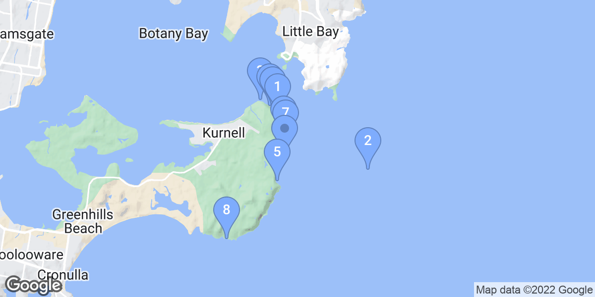
Ready to check out the best sites in Kurnell for scuba diving, snorkeling, shore diving, free diving or other ocean activities? Zentacle has 8 dive sites, snorkel spots, beaches, and more. Discover hand-curated maps, along with reviews and photos from nature lovers like you.
No matter what you're looking for, you can find a diverse range of the best ocean activities in Kurnell to suit your needs.


#1 - The Leap
Australia, NSW, Sydney
This is for experienced divers. Dive this site on the incoming tide. You have to leap off a rock into the water, but this is not the problem... If you choose to return to the entry point and NOT dive all the way round to the Steps site then you will have to exit after your dive at the same rock, which can be a problem if you dive to late on the tide and it goes out while you are submerged. Alternatively, you can exit from The Steps, only 100 meters away - as the crow flies, some 400 meters diving wise - from The Leap.
Kurnell National Park. The dive site is located after about 2 kilometres after entering the national park. You should see a small informal parking area on the right side of the road as you head up a significant hill. This is after you pass the Steps Site on the left. You will see newly painted car spaces and a Zebra pedestrian crossing painted on the raod surface as well. Its on the cleft of a corner so care needs to be taken when leaving the area and backing away from the car park. Once parked, cross the road using the zebra crossing and follow the small tack out to the east heading to the coastal shoreline. You should find a cliff walk, denoted by the stairs now made available that fishermen use down the side of the cliff face. Use this to access the site. It's not too difficult a walk. I have taken many novice divers down here. Some tollerance to heights is required though. At the base of the cliff walk you will need to be careful of black - dark green slime, which looks dry but isn't on the rocks as it is very slippery. Walk to cliff edge and perform all buddy checks. Then do a giant stride into the ocean. You need to decide before hand whether you are diving from the Leap to the Steps, or whether you are just going to dive the Leap area and come back to you start point. If you wish to take this second option, you will need to start you dive an hour BEFORE the top of the tide. This way there will be plenty of high tide to lift you up onto the rock when you wish to get out at the end of an hours dive - make it 1:30 hour before the top of the tide. If your diving from the Leap to the Steps, then you plan to do this dive 2 hours before the top of the tide, so as to gain maximum benefit of the tidal 'push' into the bay. This way you don't have to swim much at all.
Firstly, descend and then head east to great wall which drops down to the sand at 22-24 meters. Once here, turn left and head back into the bay - North west depending on air consumption, you may need to come up from the bottom and stay at 15 meters to help use less as you dive around the coast. Or you may have to completely cut the corner and rise up to 6-7 meters and come into the shallows to get all the way round the corner and make it to the Steps exit. You'll know you are back at the Steps when you are on the sandy reef line when your depth reaches 8 meters. The first few times you may need to surface first to find out where you are in relation to the Steps Exit area. This is typically where the fisho's hang out at the Steps site.
#2 - The monuments
Australia, NSW, Sydney
You should find many divers here on weekends. seek out their knowledge prior to diving.
Drive into the Botany Bay National Park and take the turn into the Visitor's car park (0.8 Km from park entrance). Pass the visitor's Centre and follow the road round (200meters) to the final car park on the left before you rejoin the main road. Turn into this car park. Covered picnic areas are easily visible from the road along with large grassed areas (hectares in size) so you'll know that you are in the right area. You access the dives site by walking towards the waters edge to the north. This is easiest done by following the natural boundary of the grassed areas and the National park's great bush area to the east towards the shoreline. You will soon see the trail in the above photo leading to the shoreline and yes there are some steps here to facilitate access to the water. However, these are very old and I would not use them to get down the small cliff (1meter high). You can find alternative access nearby. The shoreline is exposed on days with big surf so be careful picking days when you dive here. Also, check the tides as the tidal currents are strong. Aim at diving at high tide.
You should see hundreds of Sea dragons at this site, mainly near to the kelp and sand areas. They can be difficult to see and it is best if you slow the dive right down and wait for them to move about. Good dive.
#3 - The Steps
Australia, NSW, Sydney
Weedy sea dragons, giant cuttlefish, blue groper, eagle rays, octopus, moray eel, lion fish, Port Jackson shark, sea pen, numb ray, nudibranch, yellowtail, cat fish.
The Steps is located in the Kurnell Botany Bay National Park. It costs $7.00 for a day-pass to enter the national park.
#4 - The Cutting (Tabbagai Gap)
Australia, NSW, Sydney
NB. This is a shore dive for those extremely comfortable with their ability to self rescue or long surface swim. There is only one way in and one way out. If it turns to crap here while you are down you have to be able to look after yourself and may need to surface swim and good couple of kilometres home to either 'VooDoo' or 'The Steps' dive sites further round the point. generally speaking, this dive site can only be dived during August when the westerlies are blowing! This is necessary to keep the swells down. Do not attempt an entry when white water can be seen. NB: THE RESCUE SERVICES TAKE A WHILE TO GET TO THIS POINT !!!
This IS MY favourite dive site !!!
Follow Captain Cook Drive all the way out to Kurnell township. Find the entrance to the Botany Bay National Park (follow signs or ask). $8 gets you in. Follow the road all the way to the end of the road, past the whale watching site. Park in the spaces provided. Look south along the coast line to the furthest eastern point you can see, that's your dive site (but not your entry point). If you can see 'swell' producing significant white water along the cliff, then you are unlikely to be able to get in, unless you are very good and highly experienced in shore diving techniques. You CAN do it as a shore dive, ADVANCED, 300+, Divers Only! It requires a walk of 800m with all your dive gear on!, so it's not for the faint hearted, but well worth it.
Follow the green posts indicating the cliff walk-for first timers, it can be advantageous to do this once without your gear- to the cutting in the cliff face (where the pipeline is) and walk down to the shoreline. A number of ledges here on the right hand side, southern, of the cliff face are your entry points and provide good deep water to flop into. I would not suggest entering at the waters edge at its most westerly maximum as there are triangular plinths in shallow water, less than 1m, that expose you to small waves while donning and doffing your fins and make entering and exiting here difficult to say the least. Access the dive site by following the pipeline east on the south side of the cutting and then to the waters edge. Here exist some natural rock platforms which make good entry and EXIT points.
Submerge some meters off shore and follow the shoreline out to the south, see photo, following the natural shelf lines and kelp beds to the east and head south around corner. You should find a large wall drop off. Head south following the wall. Turn and head back the same way upon deciding to return home. They have recently put the DESAL pipeline in around here. Once I have had a chance to dive it again I shall update the info letting you know where it is situated and whether it causes any concerns to diving and if it-the by product-Brine, has ruined the site for diving.
Ok I have since dive the site twice after the installation of the Desal plant. Rock fall from blasting or drilling has damaged much of the natural walls look and attraction, however it still constitutes a great dive. these rocks can be distinguished from the old rocks by their sharp edges and lack of marine growth and obvious yellow colour. I have 'rec-eed' al the way to the 'spoon drain' type feature some 150meters south of the headland and can still not find the pipe for the Desal plant. So it is either underground or further south. Underground would make sense as it would provide it some protection from the large swells that frequent this location year round. The shutting down of the Caltex Oil Refinery, some years ago, has stopped the flow of warm water to the site and hence the large patches of green seaweed that used to cover the rocks near the entry have since gone. Oldly, there seems to be more fish frequenting the site now. I don't put this down to the Desal plant's operation, or the likely hood of the 'brine' affecting the water quality because the site has never operated officially. It is a big 'white elephant that contractually cost the taxpayers money to keep operational, but has never had to operate to give Sydney home-dwellers water since it opened !!! The Pipe is installed on the ocean bed some 200 meters offshore in 22 meters of water, roughly inline with the headland.
It is a shame about all the rock fall as the site was very pretty without it. But it still is a great dive on a good day !
I still rate it as the best shore dive in all of Sydney. Enjoy!
The Cutting (Tabbagai Gap) is also known as Farkernell !!(UBD), Cape Solander.
#5 - Inscription Point
Australia, NSW, Sydney
You should find many divers here on weekends. seek out their knowledge prior to diving. Also check the tides before the dive as the tidal currents are strong. Aim at diving at high tide.
The dive has a variety of fixed life (sponges and ascidians). There are numerous nudibranches and you will likely find weedy sea dragons. The sea dragons may be difficult to spot as they are usually by the kelp area.
Drive into the Botany Bay National Park and take the turn into the Visitor's car park (0.8 Km from park entrance). Pass the visitor's Centre. You will find a parking area along the road about 300 metres after rejoining the main road, usually with other fellow divers if on weekend. Gear up at the parking area and walk down the steps until reaching the shore. The entry point is about 50 metres following the shore on the left, just after passing a small rock overhang. Use the same spot for exit.
Inscription Point is also known as Captain Cook's Landing Place.
#6 - Voo Doo
Australia, NSW, Sydney
Great marine bio-diversity. Huge swim through with a ceiling with fantastic green jewel anemones on all walls, and pink & orange jewel anemones on the roof of the swim through cave, yet similar to the green ones on the walls! Great fish life. Fantastic fun watching the surfers riding the waves above. The site can be dived three ways. 1. heading south to overhang and swim through. 2. east to the deeper water. 3. southeast and around the two huge natural bommies or messas and then north homeward via the long walls. A fourth dive plan might include a LONG dive to the southeast for the sandy sea bottom and great wall. Enjoy!
If you are in Sydney City, take the road south out of the city. Follow the signs to the airport, then to Cronulla. At the junction of the Boulevarde and Captain Cook Dr, turn left and drive to the site via Captain Cook Drive, keep following the road heading towards Kurnell. Upon seeing the oil refinery take the Carbon Black road (Sir Joseph Banks Drive) and drive right to the end. Then turn right up the small national Park rd (no name) between two big rock and through the gate and follow the rd over all the speed humps and park at the end in the car park. You can see the water from here. Walk to the shoreline and seek the easiest entry into the small ocean pool. This is where you get in. Sites access is by swimming between the two big rocks at the end of the ocean pool. Head south at 210 degrees on your compass. Look for sand lines that head in the same direction as your compass heading. These are in cracks in the rock floor that aline with the walls that exist further south. So finding these is important to finding the gutters that lead to the swim through and cave over hang area.
Voo Doo is also known as Voodoo, Suck rock.
#7 - Yena Gap
Australia, NSW, Sydney
It's a very good place to meet Port Jackson sharks.
After entering the Kurnell National Park, travel along the main park road towards Cape Solander (Visitor centre, Sutherland Point). After 1,5km into the park you will see a old access road to the parking area (Yena parking area) on the left. This road has now been closed to stop rock fishermen from slipping off the rocks and being killed. So you will need to park at the top of the road and don gear here at the gate and walk to the site some 350 meters.
In the middle of the parking area, there is a trail that leads down to the cliff face. You can see the waters edge and walking trail from the top of the hill. Access the site at the marker on the map via the slopping rock covered with barnacles. You can dive this area to the north with interesting features in the shallows. Some divers prefer to enter from the point to the north of the slight headland some 100 meters from the point of the marker. Diving to the directly to the east will take you down to 27 meters at the sand, but first, over a rocky grotto full of Port Jackson sharks in winter. There is an offshore wall out on the sand and another big wall to the south, but its a long swim, interesting rock formations though. Your unlikely to see Sea Dragons here. If you wish to see them, go to "The Leap", "Inscription Point" or the "Steps" dive sites nearby. Diving to the south and close to shore you will find a number of caves and boulders in <9meters of water which can hide many Port Jackson sharks and Grouper and the other pelagic species.
Yena Gap is also known as Port Jacksons' galore.
#8 - Whale Of A Time
Australia, NSW, Sydney
Typically this site is very short on marine life and growth on the bottom. I find the site very boring and has little interest by way of features. But that is not to say that something won't swim in on the day you dive there. It makes for and interesting alternative to The Leap. Head far enough to the east and you do come to a Great Wall. But it is a bit of a swim. Best to stay shallow untIll you reach this if you are going to heading out this far. Swimming along the shore line is pretty and the only interesting area.
Drive into the Kurnell Botany Bay National park - Kamay - National park. Follow the road well into the park and past the office and parking area for the Monument. Continue to follow the road left and up the hill and following the signs to the whale watching area. Park at the end of the road in the car park provided. The cliff face is often roped off here for obvious reasons as the cliff face is sheer. Scout out to the south of the roped off area and search for the surf life saving rescue device about half way down the cliff face. You can access the cliff bottom by walking down the goat track in this area. Do this prior to gearing up and make sure you get to know the track well. Once at the base of the cliffs you c an inspect the area for the best entry and exit locations.
Whale Of A Time is also known as End of the Road.