

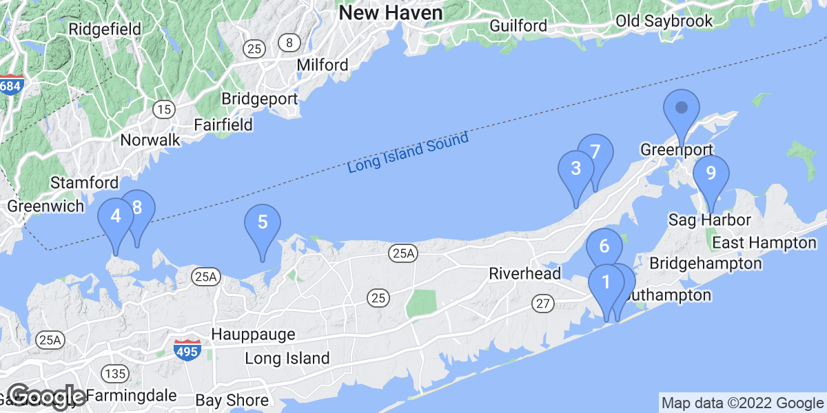
Hampton BaysMontaukBaiting HollowCutchogueEast ShorehamGreenport WestNissequogueLloyd HarborSoutholdSag HarborEast MarionMattituckRocky PointAsharoken
Top Snorkeling and Scuba Diving in Suffolk County
Ready to check out the best sites in Suffolk County for scuba diving, snorkeling, shore diving, free diving or other ocean activities? Zentacle has 17 dive sites, snorkel spots, beaches, and more. Discover hand-curated maps, along with reviews and photos from nature lovers like you.
No matter what you're looking for, you can find a diverse range of the best ocean activities in Suffolk County to suit your needs.

Recommended dive shops


#1 - Ponquogue Bridge
New York, USA East
This dive needs to be timed so that you make it at slack tide only due to the strong current. High slack tide will give you the best visibility. There are lobster and lots of other marine life. Late in the season I have even found tropical fish there brought up by the gulf stream.
Take Sunrise Highway to Exit 65 South. Make a left onto Montauk Highway, then a right turn onto Ponquogue Avenue. Take this to the end and make a left on Shinnecock Avenue. Turn right on Foster Avenue, when you see the new bridge you can turn left just before it for the northern side of the bridge. For the southern side drive over the new bridge to the end of the road and make a U-turn onto the service road.
Ponquogue Bridge is also known as Old Ponquogue Bridge.
#2 - Shinnecock Jetty
New York, USA East
Shinnecock Jetty is a 5.0-star rated scuba dive and snorkel destination in New York, USA East which is accessible from shore based on 1 ratings.
#3 - Mattituck Jetties
New York, USA East
Mattituck Jetties is a 5.0-star rated scuba dive and snorkel destination in New York, USA East which is accessible from shore based on 1 ratings.
#4 - Montauk Jetties
New York, USA East
You can drive right up to the west jetty and park free in a public lot. The east jetty can be reached through a town beach. Visibility is good with a fair amount of marine life including lobster. Diving is not permitted on the inside of either jetty due to a high volume of boat traffic.
Montauk Jetties is also known as Montauk Twin Jetties.
#5 - Lloyd Neck
USA, New York, Long Island
You can reach this site through Caumsett State Park but you will need to set this up in advance as you need a permit to drive to this site. Shore access is a short walk from the parking lot. Depth changes the further you go off shore and the greater the chance of boat traffic. Area is good for lobster and other local marine life.
From either the LIE or Northern State take the Round Swamp Rd exit north to the end. Turn right on Rt 25, left on Oakwood Rd, left on High St and right on Woodbury Rd. Woodbury Rd turns into West Neck Rd and later into Lloyd Harbor Rd.
Lloyd Neck is also known as Caumsett State Park.
#6 - Shinnecock Canal Jetty
USA, New York, Long Island
This is a long jetty with very little current except at the end of the jetty where the current can be strong at times and wakes from boat traffic can make it a tough place to swim. You can not dive on the inside of the jetty due to the current and boat traffic. There is lots of marine life with a few lobster. At low tide you can snorkel this site end to end.
Sunrise Hwy. east, after you cross over the canal take the first exit, North Shore Rd. At the end of the exit ramp go straight onto Canal Rd. north, right on Old North Hwy. and make your first left into Meschutt Park.
Shinnecock Canal Jetty is also known as Meschutt Park Jetty.
#7 - Shipwreck Cove
USA, New York, Long Island
There is no name for this cove on the chart. The site appears to have been used as a dumping ground for boats. There are a few small barges and many boats sunk here. I made this dive from a sit-on-top kayak that I put in from Cedar Beach.
The site is about 3/4 of a mile east of Cedar Beach and 4 1/4 miles west of Captree. This site can only be reached by boat.
#8 - Duck Pond Pt.
USA, New York, Long Island
This site has a sand and gravel bottom extending out to about 150 yards, after that it is mud bottom. There are large rocks and boulders close in making it good for lobster and spear fishing. There are large rocks to the west for at least a half a mile. The point itself is 1/8 of a mile east of the access point. I would recommend starting at the point towards the end of an incoming tide and drift dive the whole way down and either walk or swim back depending on the current.
LIE exit 71 north on Edwards Ave to Sound Ave east to Depot Ln north. Depot Ln turns into Duck Pond Rd, take it to the end.
#9 - Horton Pt
USA, New York, Long Island
I have made this dive from the beach and from a boat. The bottom is rocky with boulders and a fast moving current. From the beach this site needs to be timed just right. I made this dive from a boat during an outgoing tide and it was like an underwater roller coaster taking you over boulders as big as a two story house.
LIE exit 71, Edwards Ave north to Sound Ave east to Horton Ln north. Bear right onto Old North Rd and left onto Lighthouse Rd to the end. There is parking at the lighthouse and a long stairway down to the beach. The stairway is about 125 steps long so do not attempt this dive if carrying your equipment back up is going to be a problem.
Horton Pt is also known as Horton Pt Lighthouse.
#10 - Greenport Jetty
USA, New York, Long Island
This is a great place for a large assortment of marine life including lobster. The area is sheltered from wind in most directions but boat wakes can be a problem on weekends. The current can be a problem at the tip of the jetty during peak tide change. The site is well worth the drive and walk.
LIE to exit 71 north on Edwards Ave, right on Sound Ave [long drive] turn right on Manhanset Ave to the end. Klipp Park Beach is at the end of Manhanset Ave, it is a local beach but you can buy a day pass. You can walk the 1/3 of a mile to the jetty or put a boat in at the Klipp park ramp.
#11 - Shoreham Jetties
USA, New York, Long Island
The visibility is great and the current is very low if at all. Lots of marine life and lobster. This is not the easiest place to find or get to but well worth the trip. Over the years this site has filled in with sand so at low tide you can snorkel about 80% of this site.
Long Island Expressway to Exit 68 North, Wm. Floyd Parkway to the end and make a right on to Rt 25A. Make a left onto Randall Rd. Make a right onto North Country Rd. Make a left on Sound Road to the end. Turn left on Creek Road to the end, where you will find a small parking lot. To get to the jetties, you must swim or walk across the creek (Wading River), and then walk to the jetties. Total distance is about a quarter of a mile to the east jetty. I use a sit-on-top kayak to get from the lot to the jetties, this also makes it easy to get to the west jetty where I usually find more lobster.
Shoreham Jetties is also known as Shoreham Power Plant.
#12 - Sag Harbor Jetties
USA, New York, Long Island
The site is made up of two jetties that are the barriers for the harbor. The first starts at the beach and goes out about 350 yards. There is a 30 yard gap between the first and second jetty, the second jetty is about 600 yards long. Other then the jetties the harbor itself can be interesting dating back to the 1600s but there is a lot of boat traffic to deal with once you get away from the jetties.
Montauk Hwy Rt 27 east to Bridgehampton. Take Bridgehampton / Sag Harbor Turnpike north, turns into Main St and ends at the harbor. Though the jetty starts on the beach there is no way to get to it that I know of so this needs to be a boat dive. I have made this dive from a sit-on-top kayak.
Sag Harbor Jetties is also known as Sag Harbor.
#13 - Roanoke Pt Ships
USA, New York, Long Island
There are 4 wood hull boats sunk off the beach. 3 in a line, 1 half buried on the shore and another half buried boat about 200 yards away. The access to the beach is about a half a mile east of the site. I use a sit-on-top kayak to get there and dive but most people will have to walk. Visibility is good with lots of marine life and lobsters.
Long Island Expressway to Rt 24 Exit and go north on Edwards Ave. Turn right onto Sound Avenue, and make a left onto Park Road and take it to the end. The boats are about 1/2 miles down the beach to the west.
Roanoke Pt Ships is also known as Roanoke Barges.
#14 - Sound Beach
USA, New York, Long Island
The site has a rocky bottom with lobster and other marine life.
LIE to exit 63 north to the end, right on 25A, bear left onto Echo, right on Lower Rocky Pt Rd, left on Hegerman Landing Rd to the end. There is no parking at the site itself so you will need to drop your gear there and park else ware.
Sound Beach is also known as Hagerman Landing.
#15 - Gwendolyn Steers Wreck
USA, New York, Long Island
The Gwendolyn Steers is a tugboat that sunk in about 55ft of water. The wreck sits upright and comes to within about 25ft of the surface. It is 96ft long with a 20ft beam. Visibility is usually poor, there is a fair amount of boat traffic and nets have been present in the past.
Access is by boat only.
Gwendolyn Steers Wreck is also known as Gwendolyn Steers.
#16 - Rocky Point
USA, New York, Long Island
The site has a clean sand, pebble and rocky bottom. Lots of rocks and a fair amount of lobster and other marine life around them. The current is strong here at times and visibility is good. Slack tide would be the best time to dive this site.
LIE to exit 71 north on Edwards Ave, east on Sound Ave, north on Rocky Pt Rd to the end. The site is at the bottom of a 20ft bluff.
Rocky Point is also known as Rocky Pt., East Marion.
#17 - Smithtown Bay Artificial Reef
USA, New York, Long Island
Reef is made up of a barge and tires. Lots of marine life including lobster.
Site is about a mile offshore and can only be reached by boat. The site is sometimes marked by a buoy but due to a fair amount of boat traffic that is not usually the case. Without a GPS you will have a very hard time finding this site.