

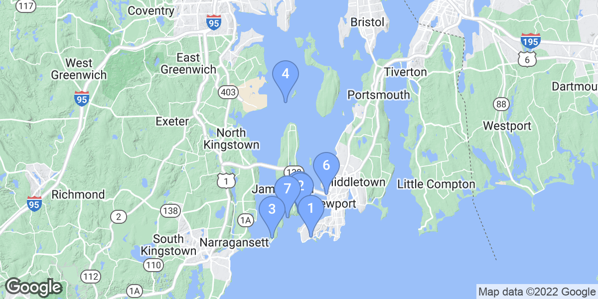
Top Snorkeling and Scuba Diving in Newport County
Ready to check out the best sites in Newport County for scuba diving, snorkeling, shore diving, free diving or other ocean activities? Zentacle has 7 dive sites, snorkel spots, beaches, and more. Discover hand-curated maps, along with reviews and photos from nature lovers like you.
No matter what you're looking for, you can find a diverse range of the best ocean activities in Newport County to suit your needs.


#1 - King's Beach Fishing Area
Rhode Island, USA East
A lovely, almost secluded beach area that leads down an old boat ramp to an easy entry into about 20-30 fsw after a short to moderate swim. Lots of eel grass, flounder, small fish, and other life. Not an amazing dive but it does the trick. Frequented by classes on weekends so it may get crowded. Viz ranges from 3-20 feet, mostly about 8-10 on a calm day.
Route 138 east takes you to the Jamestown bridge. Continue over the Newport Bridge and exit at Scenic Newport. R on Farewell, R on America's Cup Ave, R on Bellevue, L on Ocean, to sign on L for King's Beach Fishing Area. Drive to the parking lot, plenty of room, not crowded, and free. GPS: N 41 27.234 W 071 20.543(parking lot)
#2 - Fort Wetherill
Rhode Island, USA East
Fort Wetherill is a scuba location with two dive sites. The left and right cove. The left cove has a small goat path down to the water. The right cove has a boat ramp entry, can get busy so yield to boats. Both coves have okay viz. (3-10 feet) and have pretty good life. Averages 5 feet but classes frequently drop the viz to less than 5, still plenty of room though to get away from groups. Flounder, fish, starfish, crabs, lobster, eel grass. I believe the left cove along the right wall is the best of the two. Porta potties. Easy and plentiful parking.
Route 138 east over the Jamestown Bridge, exit just before the toll booths, straight on Narragansett, bear left at the fork, follow signs to the park. Plenty of parking close to the entries. GPS: N 41 28.774 W 071 21.618
#3 - Beavertail State Park
Rhode Island, USA East
Easy parking, abundant fish and bottom topography, but a pretty steep entry down a rocky hillside to a small and pretty cove. This site isn't very protected so make sure to take a look at the entry and conditions before suiting up. The park is basically located at the end of a point. Man is it lovely here! Best diving is about 50 yards straight out into 30 fsw.
Route 138 east to the Jamestown boat yard, R on Narragansett, L on Southwest, turns into Beavertail Rd to parking lot #2 in the park. GPS: N 41 27.074 W 071 23.971
#4 - Ft. Wetherill
USA, Rhode Island
This is a popular site in Rhode Island. Ft. Wetherill, Jamestown. 3 possible entries, from the parking lot, facing the water. To your right is a boat ramp, this is where the open water classes take place. It is also a deep dive if you travel along the left wall of the cove to the end where it drops to about 100'(33m)
You can also enter the left cove, a short walk down a narrow path and a steep hill. Here you will follow along the right wall of the cove and end up in the same area if you go to the end of the wall.
You can also enter through the DEP station(Bull Point) this is a pretty tricky climb down a rock hill. once in the water it is a shorter swim to hit deeper depths. Avoid this entry with any kind of wind out of the south west.
This is a state park. Drive in, park, dive.
Ft. Wetherill is also known as jamestown.
#5 - Van Zandt Pier
USA, Rhode Island
Great spot for clams! Usually spot striped bass under the bridge
Park along seawall on Washington St. Enter water from beach or end of pier
#6 - Horsehead
USA, Rhode Island
Descend gradually to depths as deep as 60 feet - as you follow the western reef perimeter, depth increases beginning with scattered large rooks with many lobster crevices and anenomes. Gradually swim deeper into large shelf overhangs and shallow caves. There are many areas to explore, but watch your air for the possible against current swim back to the boat. It's best to dive during slack tide and wait for a northern wind direction prior to diving for best visibility.
Boat access only. Enter Mackeral Cove, Jamestown, RI from the south via Rhode Island Sound - just north of Kettle Bottom Rock (another good dive site w/wreck remains). Boats under 30-32 feet may drop anchor inside the first small cove on the eastern shoire of mackeral Cove. Larger boats need to drop anchor just outside this small cove off Horsehead. Gear up, descend and follow the perimeter reef - heading southeast.
Horsehead is also known as Mackeral Cove.
#7 - Mount Hope Tug Boat
USA, Rhode Island
Lying shallow in 6-7m of water, this wreck is just submerged and can be seen from the surface at low tide. Be careful approaching the site since you can run your prop into the wreck at low tide.
Visibility is terrible in the summer but can be a nice easy dive prior to May or after October. If you like spearfishing, big tautog (blackfish) can be found here in early spring and late fall in the remains of the wheel house and around the wreck.
Tug boat is Steel Hull American 156 tons. 118ft long. Lost 02/18/1968
This is a tug boat wreck located to the southwest of Hope Island in Narraganset Bay. It is located in the middle of the bay and is easily accessible by boat from Wickford, Allen's Harbor, Jamestown, Newport and other local marinas and boat launches locations.