

Top Snorkeling and Scuba Diving in Nanaimo
Ready to check out the best sites in Nanaimo for scuba diving, snorkeling, shore diving, free diving or other ocean activities? Zentacle has 11 dive sites, snorkel spots, beaches, and more. Discover hand-curated maps, along with reviews and photos from nature lovers like you.
No matter what you're looking for, you can find a diverse range of the best ocean activities in Nanaimo to suit your needs.

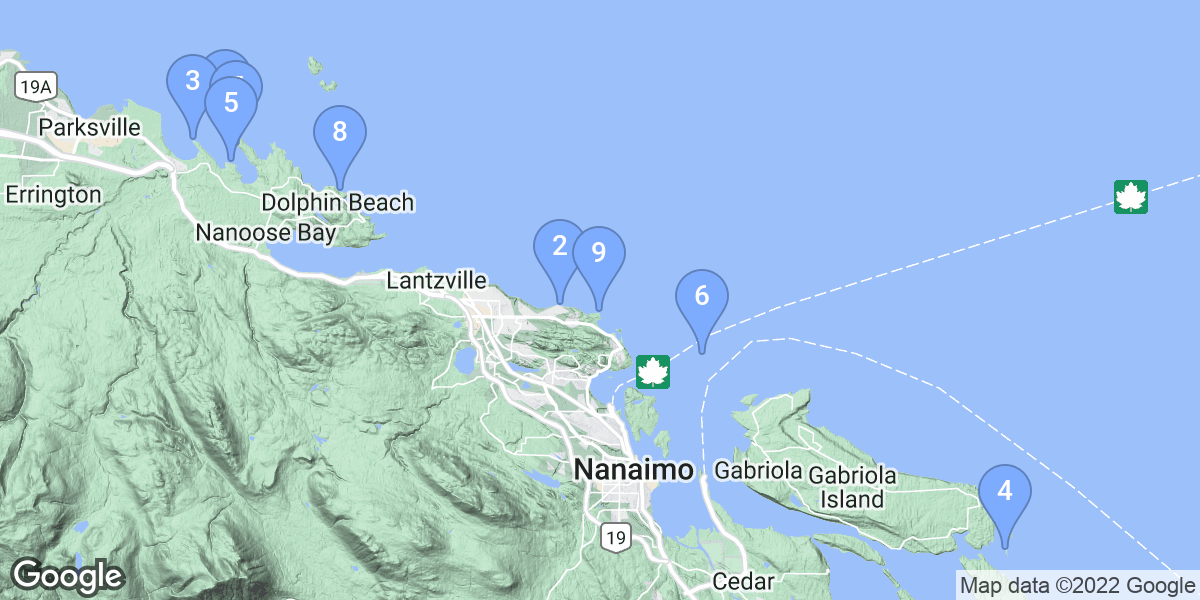


#1 - Madrona Point
Canada, British Columbia, Vancouver Island
There are two walls here. One as you enter the water, and a much deeper wall whose top starts at about 40 feet and descends below 100 feet. For first time divers, the left most path to the water gives a good starting point as it's easy to enter and the depth is about 20' or so. Watch your footing as there is lots of seaweed on the rocks when the tide is out. There is a channel cut into the rock and can make entering easier then jumping from the rock edge. The second wall most western end can be found at roughly 360 degrees magnetic north. Follow the path from the vehicles straight out to the water (roughly north)and enter the water in a shallow channel. You will have a surface swim of about 500' or so, head out at a North East heading (you can see a snow covered peak in the distance - aim for that)and then descend.
The two walls have lots of life on them, there are wolf eels on the outer wall and octopus on both. Crab, lingcod, dogfish etc... can also be seen here and at times the seals will visit.
In the spring,summer the visibility can be tough at times (10' or less)but usually at depth it improves. Winter is the best but we have had awsome vis (80' plus)in June. It just depends on the plankton bloom.
Follow the Island Hwy north towards Parksville, at Nanoose Bay you will come across Northwest Bay Road at the set of traffic lights. Make a right on to it. Follow Northwest Bay Rd for a few kilometers, and make a right onto Arbutus Drive, then a left onto Madrona Drive and follow it to the end. About a kilometre. The end of Madrona Drive is the parking lot. There is only room for about four cars here. Once your parked, there is a bit of a hike down to the shore. Follow the path and once through the clearing, turn left to go to the shallow wall or go straight (follow the "V" in the rock) to enter for the far wall.
Madrona Point is also known as Madrona Wall.
#2 - Wall Beach
Canada, British Columbia, Vancouver Island
Varied wildlife, Octopi, Wolf Eels, Ling Cod, Anemone.
Park at the end of the street and follow the short path 20 to 30 ft to shore.
#3 - Break Water Island
Canada, British Columbia, Vancouver Island
This dive site is sensitive to current. It has an interesting rock structure, with homes for a few wolf eels. I'd rate this dive between standard and good.
This is strictly a boat dive. And either use a local charter or Google Earth to locate this dive site.
#4 - HMCS Saskatchewan
Canada, British Columbia, Vancouver Island
HMCS Saskatchewan was a Mackenzie-class Destroyer
Escort of 366-feet (111 metres), 2900 tons.
Sunk in 1997.
off Snake Island, near Nanaimo
HMCS Saskatchewan is also known as DDE 262, DDE-262.
#5 - Beachcomber Deep Wall
Canada, British Columbia, Vancouver Island
The dive: Swim out a minute then hang right and find the 30 ft contour. Swim a few minutes until you find the shallow wall (4 mins or so). Pass this wall start going down over the boulder field (bottoms at 65 ft or so) and stay along that coutour continuing NW. A short while - 12 mins from the beach - you start seeing the bedrock at the start of the wall. Crenelated at first, angle down to say 95 ft. When you reach the cable, swim just a bit further then go down deep. Bottoms well below 250 ft, on the chart says almost 300 ft. Overhanging skyscraper type wall in places. I have hit 234 ft.
Beach access is at Beachcomber Regional Park, on Cottam Point, north shore of Northwest Bay. Walk trail to beach (nice gravel at high tide, slippery larger rocks at low tide) and enter.
#6 - Snake Island
Canada, British Columbia, Vancouver Island
Snake island is a Bird Sanctuary, and home to approx 200 Harbour Seals. Great snorkeling & scuba.
Snake Island is located 3 kilometers from Departure Bay in Nanaimo, approx a 10 minute by boat ride.
#7 - Beachcomber South Wall
Canada, British Columbia, Vancouver Island
The dive: Continue down, the slope steepens until around 85 ft then really steepens, by app 115 ft becomes close to vertical. There is a large fishing net draped over the edges. Some cloud sponges below 160 ft. Imagine a 15 story wall 4 minutes swim from the beach.
Park off road near obvious trail near the Beachcomber Regional Park sign. Walk down trail to beach (nice gravel at high tide, slippery larger rocks at low tide). Enter and swim directly magnetic south, perhaps angling a little left over the clam beds till you find the rocks.
#8 - Dolphin Beach
Canada, British Columbia, Vancouver Island
Follow the Island Highway from Nanaimo. Then turn off at Nanoose Bay onto Northwest Bay Road then follow it until you can make a right onto Steward Road. Follow it until it turns into Davenham Road then into Dolphin Drive and then keep an eye out for Tyee Crescent. Then just park beside the mail boxes, at the corner of Tyee Crescent and Dolphin Drive.
Dolphin Beach is also known as Tyee Crescent Beach.
#9 - Neck Point
Canada, British Columbia, Vancouver Island
If coming from the Ferry Terminal make a left onto Brechin Road just as you leave the Departure Bay Ferry Terminal area. Follow it up to the lights, staying on the right side of the road. When you get to the lights you will be making a right onto Estevan Road - which almost immediately becomes Departure Bay road. Follow Departure Bay Road and after you pass the beach at the bottom of the hill, make a left onto Hammond Bay Road. Follow this for a few kilometers then make a right onto Morningside Drive and drive past the school, and you will see the sign for Neck Point. You will need to park in the lower parking lot. The main one shown on the web page: www.Robots4Farms.com
If you know someone in town, then there is a key to the parking area closer to the dive site.
Neck Point is also known as Neck Point, Nanaimo.
#10 - HMCS Cape Breton
Canada, British Columbia, Vancouver Island
The HMCS Cape Breton (ARE 100) was built in 1944-45 in British Columbia by the Burrard Drydock Company and served in the United Kingdom's Royal Navy as Flamborough Head. In 1951 she returned to Canada under the ownership of the Royal Canadian Navy, renamed Cape Breton and re-assigned as a training vessel at Halifax, Nova Scotia. In 1958 she sailed for Esquimalt, B.C. and was converted to an escort maintenance vessel. Cape Breton was re-enrolled on November 16, 1959 and served as a repair ship at least until February 10, 1964 when she was paid off into reserve.
The HMCS Cape Breton was a 411 ft. escort maintenance ship and sunk October 20, 2001 in 145' ft.of water. The largest diver prepared artificial reef on the coast, its crows nest can be reached at 40 ft., top of funnel 50 ft., captains quarters 85 ft., for and aft decks at 100 ft. and the engine room reached at a depth of 140 ft.
Specifications (from Wikipedia):
* Commissined: 1944; 1952
* Paid off: 1952; 1964
* Displacement: 8580 tons
* Length: 441 feet
* Width: 57 feet
* Draught: 20 feet
* Top Speed: 11 knots
* Crew: 270
* Armament: none
HMCS Cape Breton was sunk and now lays near Snake Island in Nanaimo harbour.
Three Tie up floats, Sits Bow Pointing North.
HMCS Cape Breton is also known as ARE 100.
#11 - Rocky Point
Canada, British Columbia, Vancouver Island
The water quality varies here quite a bit. So, this location may only be good some of the time, partly because it is shallow here. If the conditions are not good above 50 feet, then you should dive Neck Point or Dolphin Beach.
If you're starting out from the ferry terminal you need to get on to and follow Hammond Bay Road, and assuming your coming from the south, make a right onto Entwhistle Road and follow it until you can make a right onto Fillinger Crescent. Keep an eye out for the bear statue and the actual address is 5040 Fillinger Crescent. You should see the bears their holding the street address at the entrance of this old boat launch. Plenty of parking at this dive location. The waters here are fairly shallow and most of your diving will probably be above 50 feet [16 metres].