

Top Snorkeling and Scuba Diving in Victoria
Ready to check out the best sites in Victoria for scuba diving, snorkeling, shore diving, free diving or other ocean activities? Zentacle has 7 dive sites, snorkel spots, beaches, and more. Discover hand-curated maps, along with reviews and photos from nature lovers like you.
No matter what you're looking for, you can find a diverse range of the best ocean activities in Victoria to suit your needs.


#1 - Ogden Breakwater
Vancouver Island, BC, Canada
Ogden Breakwater is a marine preserve with features created just for divers. A very easy entry marks the start of a diving 'scavenger hunt' for the sunken plaques that line the break water. Each plaque contains information about the area and marine life you'll encounter.
From the inner harbor of Victoria, drive South 1.5km to the end of Government Road, and turn right on Dallas for 1km.
#2 - McNeill Point
Vancouver Island, BC, Canada
McNeill Point is an exciting spot to explore, but only during ideal conditions. The tidal currents through here could ruin your whole day if you're not careful. Check with a local dive shop about seasonal and hourly conditions at this site!
Located 0.4km West of the Victoria Golf Course on Beach Road.
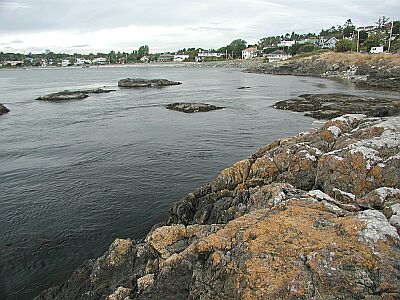
#3 - Ten Mile Point
Vancouver Island, BC, Canada
Ten Mile Point can offer some great sights for the advanced diver. A constant current of varying strength keeps this area alive with sea life. You can stay in the shallows to explore the shore, or quickly drop down to 30 meters to investigate the nearby wall.
Our best advice is to get a map of Victoria once you arrive, and locate the general area of the point in the Cadboro Bay district. Find Tudor Ave which runs the length of the small peninsula, and head Southeast. Tudor will eventually bend to the left; in 300m, take a right on Baynes Road, then a left on White Rock. You'll see the intersection below.
Ten Mile Point is also known as Whiterock Street.

#4 - Ogden Point Breakwater
Canada, British Columbia, Vancouver Island
The Ogden Point Breakwater is an 800-metre long breakwater constructed of stacked granite blocks and concrete. Although the breakwater is a marine sanctuary, line fishing is allowed; be alert for fishing gear on the bottom and overzealous boaters.
There are five dive flags painted near the top of the west side of the breakwater, with corresponding bronze plaques at the bottom stone of the breakwater directly in line with each flag. The plaques provide a description of the marine life in the area, and the compass bearing to the next plaque.
Entry is from the beach, breakwater or dive boat. Caution must be exercised when entering from the breakwater due to the barnacles and concrete blocks obscured by bull kelp.
Beach to Flag 1: Mixed cobble and sand bottom, shallowing slowly to 8 metres.
Flag 1: 8 metres depth, sand bottom.
Flag 2: 8 - 17 metres depth, sand bottom.
Flag 3: 17 - 20 metres depth, sand bottom.
Flag 4: 22 - 25 metres depth, sand bottom, rubble below 9 metres.
Flag 5: 28 - 35 metres depth, mud, sand bottom, tumbled granite blocks.
The marine life in this area is abundant and varied. Expect to see the following: Sleeping Canary, Tiger, Black, Yellowtail, Puget Sound and Quillback Rockfish, Octopus, Harbour Seals, Dogfish, Rat Fish, Wolf Eels, Black Eye Gobys greenling, lingcod, Perch, Flounder, Kelp Greenling, Grunt Sculpins, Decorated Warbonnets, Mosshead Warbonnets, Burrowing Sea Cucumbers, Chitons, Hairy Lithoide Crabs, Brittle Stars, Metrudium and Plumose Anemones, Abalone, Crab, Puget Sound King Crab , Swimming Scallops, Ghost Shrimp, and Nudibranchs.
There is a dive shop, the Odgen Point Dive Shop, located at the end of the breakwater where you can conveniently get air and rental gear.
Odgen Point Breakwater is located at 199 Dallas Rd, Victoria, BC. It is right next to the Helijet airport and the docks where the cruise ships dock. There is a parking lot with paid parking right by the dive shop, with a few stairs to get to the breakwater itself, or follow the path around to the beach.
Your entry and exit points can be anywhere along the breakwater, from a minute's walk to a half hour hike from the end.
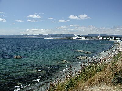
#5 - Albert Head Lagoon
Vancouver Island, BC, Canada
Albert Head Lagoon is another wonderful no-current dive for searching out crabs and skates. This site is really off the beaten path, so bring everything you need for a comfortable day.
From Victoria Harbor, take the Trans-Canada Highway (1) to the North. In 9km go South on Highway 14 (Old Island Highway). In 4.5km turn left on Metchosin Road and travel for 3.6km until you reach Albert Head Lagoon Regional Park.
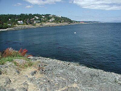
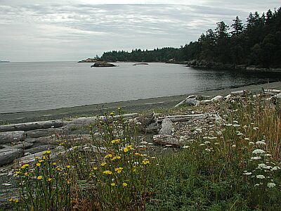
#6 - Clover Point
Vancouver Island, BC, Canada
Clover Point is a no-frills park used by most to contemplate the coastline and sea beyond. But what make this area worthwhile for the diver is the point and the surrounding marine life. Kelp and creatures will keep you company on this dive.
From the inner harbor of Victoria, drive South 1.5km to the end of Government Road, and turn left on Dallas for 1.9km.
#7 - Willis Point
Vancouver Island, BC, Canada
Diving here is great! When you finally climb down the rocks using the tree on the right for help. Swim about 100ft from shore then descend. If you swim to the left and out a bit you will come to a sheer wall that drops to 110ft! It is covered in life and in the deeper depths you may find some Cloud sponges. I usually swim on the surface past the 3rd house(left if you are facing away from shore) descend to the wall then to 100ft. I work my way up the wall while going back to the entry point for my safety stop in the kelp beds.(it gives my something to look at) - Geoff
Head north on the Pat Bay Highway (#17) turn off, then left at the Royal Oak Dr. overpass (look for the sign) follow Royal Oak Dr. till you get to West Saanich Road. Follow north 6.5km , turn left onto Wallace a Dr. then when you see Willis Point Rd. turn left (the only way to go) Follow all the way to the end (8.2km) where you will find Mark Lane. Turn right and drive down about 0.6km to a fire lane on the left. Do not park right in the lane and be careful not to block peoples driveways. I believe the address of the last house before the fire lane is 7442.
To find this on a map it is best to enter into Google Maps or Map Quest: Steamer Drive, Brentwood Bay British Columbia - then look for the fire lane as you are driving along. Its beside a black iron fence. If you encounter Steamer Drive itself, you have just gone past the fire lane. Do not block the fire lane as this is for the fire trucks to get water from the ocean. But there is parking for at least 4 cars here.