Difficulty
Unrated
Viz (last reported 107458h ago)
Max Depth
Unknown
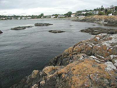
Snorkeling and Scuba Diving at Mystery Wreck in Deep Cove
Dive off the end of the dock (left side) and swim out to the marker buoy. Descend down the line vis may be bad on the surface but around 20ft it will clear up. Swim along the bottom on a heading of about 90* and you should co to a reef with a sunken speed boat on the side to it swim a little further and the wreck will appear out of the dark (it looks rather eerie). No one knows the name or who owned it. I start by swimming along the side then at the end I swim through the middle with the wreckage coming out of the bottom all around me. There are big schools of fish that may follow you around , plume enimnies , nudeabranks, crabs and other such life. It is a large wreck (165ft long) so it may take two dives to see the whole thing but I have been 6 times I still love going there. When you pay ask which buoy to go to as there are a few and they change places a lot. There is no current to speak of even on large tidal exchanges. Even during not so good weather when you can not dive anywhere else you can dive here! Have fun! - Geoff
<br><br>
Additional Information from Bryan Heit:
<br><br>
1) The ship is a train barge which sunk in the 1950's (not 100 years ago
as listed). The barge struck a reef just outside the harbor and limped
in - only to sink about 100' away from the dock! No one knows who the
owner was, nor the name of the ship.
<br><br>
2) The buoy which you dive to is the faded pick spherical buoy, located
at about a 45 degree angle to the right of the dock when standing in the
parking lot. This has been the same buoy for several years.
<br><br>
3) At the bottom of the buoy is half of a speed boat. According to the
owner of the marina this boat sunk in 2001 when he was towing it - the
owner hadn't paid their dockage fees. A great picture opportunity is to
get a photo of someone "driving" the boat.
<br><br>
4) The barge itself is in poor condition, and penetration should not be
attempted. Large sections of the wreak have collapsed in, making any
penetration dangerous. But there's a lot to see on the outside,
including ling cod, grenlings and purch.
<br><br>
5) As mentioned the marina owner is really nice, and will fill tanks for
$5, including parking.
<br><br>
6) Another (free) entry option:
Take highway 17 towards the ferry terminal, to Wain Rd. Take Wain west
until it ends, turn right (north) onto the road at the end of wain
(mardrona drive). Follow this 3-4 blocks until you reach Setchel Rd.
Turn left, follow the road to it's end, and park in the cul-de-sac.
Take the path down to the point, and dive from there. The wreak is to
the left. If you dive from this spot swim along the bottom to the wreak
- there used to be an old Chinese colony here and there is a tone of
debris to see, including a lot of old bottles.
<br><br>
7) Dive this dive at the end of high slack. There is too much silt at
low tide, but if you wait for high slack vis increases dramatically.
<br><br>
8) As this is a marina you should fly a dive flag.
from Victoria take the Pat Bay Highway (#18) towards the ferry terminal but just before it take the Wain Rd. exit. Follow Wain Rd. all the way to a four way stop (Madrona Dr.) turn right onto Madrona Dr. then turn right again and look for the Deep Cove Marina their address is 10990 Madrona. Phone # (250) 656-0060. They charge $3 per diver to dive off the end of the dock (secured parking included). They also have an air station there and last time I was there he charged me $5 to fill my tank but waived the $3 dock/parking fee. You can dive off a near by point but it is a long swim and limited parking. It is well worth the $3! - Geoff
Access
shore
Nearby Shops
Tide Report
5
4
3
2
1
(5)

Milo
Apr 27, 2014, 12:00 AM
scuba
I used to keep my boat at this marina and this barge was purchased and moored there by the then owner of the marina. He moored it at that location and used it as breakwater from winter northwest winds. The coast guard objected and ordered it removed but there was a lengthily dispute over it. Eventually the owner put a light on it as it almost impossible to see at night. It continued to decompose and eventually sank.
Originally posted on shorediving.com
Tyler Newman
Sep 2, 2007, 12:00 AM
scuba
First 20' poor vis, below that 20-30'. Easy to find: take a bearing of 90 degrees of Seychelles Point. Very eerie wreck. Saw a dogfish, lots of skates and rockfish. Wreck has deteriorated quite a bit. Good dive
Originally posted on shorediving.com
Bryan Heit
May 28, 2004, 12:00 AM
scuba
An interesting dive, although conditions can vary greatly. The first time I dived this site (at low tide) we had minimal visibility, and there was almost no life to be seen. Second time I dove this site the vis was up to 30 or 40 feet, and there were several large schools of fish around the wreck. The wreck itself is really starting to disintegrate, so be careful as you may get snagged. As mentioned in the description the wreck itself is huge, and if you look around there is a lot of neat things to see. Definitely worth a visit or two!
Originally posted on shorediving.com
Noel Currie
Jan 27, 2004, 12:00 AM
scuba
Ignore the 'ratings'; they're all set at default levels. This is 'THE OWNER' speaking! Sorry to disappoint you, but there is no Mystery, only a wreck. The wreck is that of an ex-railway services barge which was actually moored to the NW of the Marina dock as a protective breakwater. It sank in a NW storm some time in the 1970's (or possibly 60's, so I am told by 'old-timers' who live here). To the Northwest of the wreck, you can still see some of the old railway locomotive wheels in the mud (or you could 5 years ago, which is the last time I looked). I'm sorry to inform you that the fill station no longer exists. Not enough business, so I sold the equipment to Sidney Dive & Surf, a new dive shop which opened in Sidney (about 7 Km away).
Originally posted on shorediving.com
Anonymous
Jun 8, 2003, 12:00 AM
scuba
I've often heard the visibility can be bad at this site, but every time I dove it, visibility was about 50-60 feet (good for here)- Avoid this site in the late spring and early summer. Lots of perch schooling in the wreck. It is pretty crumbled except for the iron bolts and some remaining planking sticking up about 10 feet from the bottom. the bow is mostly intact (made of metal). Near the stern, there is a large metal water or fuel tank and some piping and valves. Could this barge have been a floating gas station? They were pretty common at the entrances to marinas back then. If you swim around the sand away from the wreck towards the shore, there is a lot of old, interesting junk and bottles scattered about. If you swim out from Setchell Point, there is a reef that goes down to about 70 feet deep. There are several smaller reefs past this out on the sand. Not much life on the main reef, but there are huge plumose anemones and lots of rockfish on the smaller ones.
Originally posted on shorediving.com
Other Locations Nearby